Badme Is on Eritrea's Side of the Line: Checking Ethiopia's '60 km' Against the 2002 Ruling
An Ethiopian diplomat lists Badme as a town Eritrea has invaded. The 2002 border ruling, which Ethiopia accepted in 2018, puts Badme in Eritrea. Adulis News measured every place Ethiopia named against the line: one is on Eritrea's side, and none is near 60 km in.
By Adulis News · · 6 min read
An Ethiopian diplomat said this week that Eritrean troops “have taken up positions in Rama, Sheraro and Badme”. He called it a violation of Ethiopia’s sovereignty. But Badme is not in Ethiopia under the border ruling that both countries agreed would be “final and binding”. In 2003 the Boundary Commission said Badme village lies on Eritrea’s side of the line. In 2018 Ethiopia’s ruling coalition said it would fully accept that ruling.
Ethiopia also told the UN Security Council that Eritrean forces had pushed “up to 60 kilometers” into Tigray. So Adulis News checked Ethiopia’s claims against the map. We took the 2002 line from the Commission’s own coordinates and measured how far each place Ethiopia named lies from it. The farthest is about 35 kilometres from the line. One of them is on Eritrea’s side.
What Ethiopia says
Ethiopia’s foreign minister, Gedion Timothewos, wrote to the Security Council on 8 October, according to The Reporter, an Addis Ababa newspaper. It says the letter describes advances in three sectors: “the Badme–Sheraro–Shimelba axis in the northwest, central border towns such as Rama and Adwa, and eastern districts near Zalambessa and Adigrat”. It says the letter puts the depth at “up to 60 kilometers”. Reuters and Al Jazeera also reported the 60-kilometre figure.
A second letter, dated 9 October, invokes Ethiopia’s right to self-defence under Article 51 of the UN Charter. According to AP, that letter “did not identify the occupied areas or provide evidence”. Neither letter is on the UN’s public document system yet. The Reporter says an evidence dossier came with the first one. Its contents have not been published.
On 13 October, Ethiopia’s Consul General in Bahrain, Ambassador Shiferaw Geneti Jena, went further. According to News of Bahrain, he said Eritrean troops “have taken up positions in Rama, Sheraro and Badme, and along the Adigrat–Zalambessa corridor”, and called this “a serious violation of Ethiopia’s sovereignty and territorial integrity”.
What the 2002 ruling says
After the 1998–2000 war, both countries signed the Algiers Agreement in December 2000. They set up the Eritrea–Ethiopia Boundary Commission and agreed in advance that its decision would be “final and binding”. The Commission heard both sides at the Peace Palace in The Hague and gave its decision on 13 April 2002.
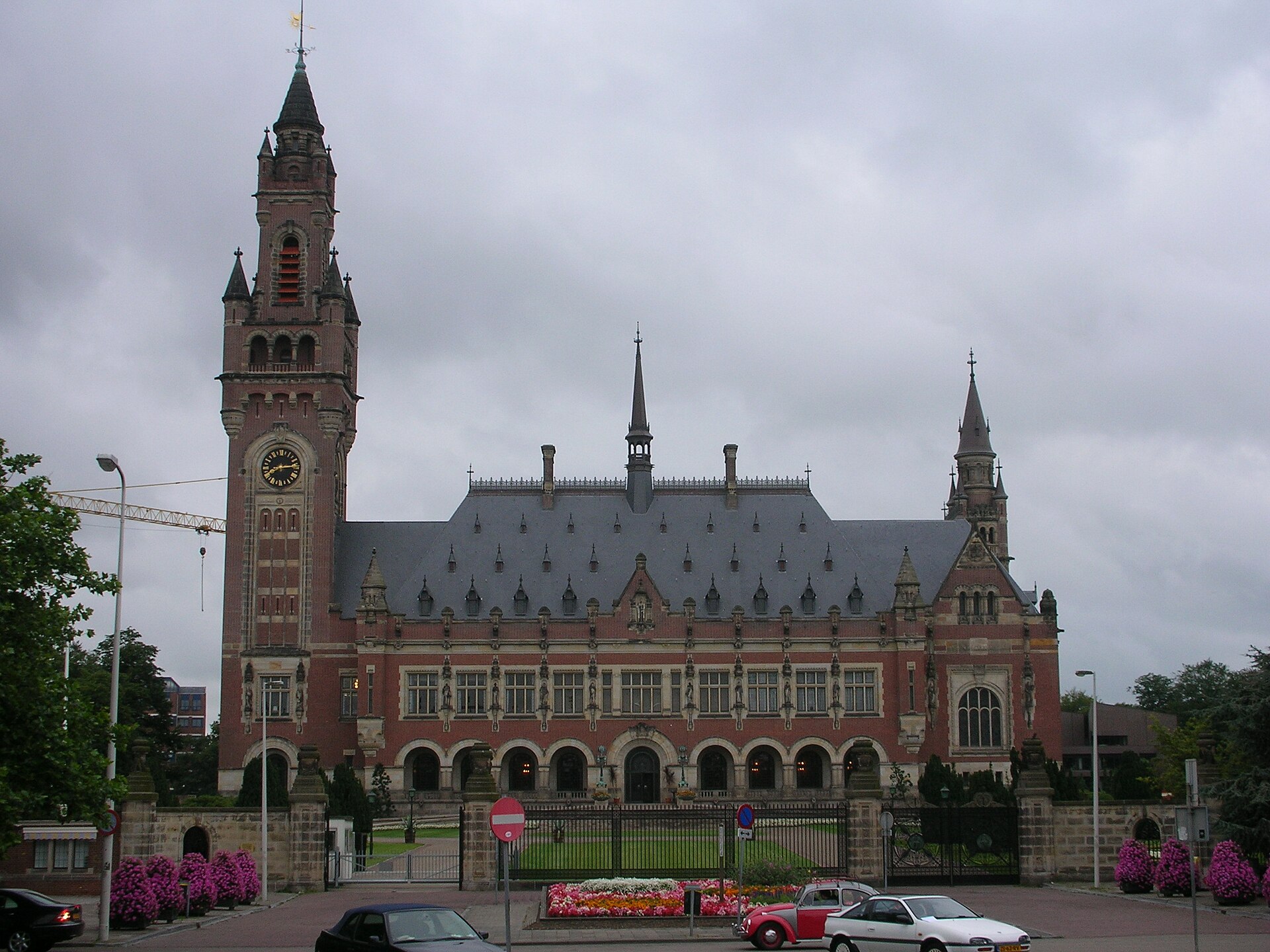 The Peace Palace in The Hague, where the Boundary Commission held its hearings in December 2001. Photo: Kent Wang, 2005, Wikimedia Commons, CC BY-SA 2.0.
In the west, the decision is simple. From the point where the Tomsa river meets the Setit, “the boundary turns to the northeast and runs in a straight line” to the point where the Mai Ambessa meets the Mareb. From there it follows the Mareb east. The US State Department’s geographer published the coordinates of these points in 2003, and told US mapmakers to treat the line as the “interim de jure international boundary”.
The decision did not name Badme. Ethiopia asked the Commission to explain. On 21 March 2003 the Commission answered. According to the UN news agency IRIN, it said that “Badme village, as opposed to some other parts of Badme region lay on what was found to be the Eritrean side of the [1902] treaty line”. It added that “the maps submitted by Ethiopia were inconsistent as to the location of Badme village”. The Dutch scholar Jon Abbink wrote the same year that the statement settled it: Badme “would be in Eritrea”.
Ethiopia backed away. According to Addis Standard, as reported by Africanews, Prime Minister Meles Zenawi said Ethiopia would accept the decision only “in principle”. Then, on 5 June 2018, the executive committee of Ethiopia’s ruling coalition said the country would fully accept the Algiers Agreement and the Commission’s decision. As Africanews reported that day, this meant Ethiopia “will have to withdraw its occupying forces from all territories awarded to Eritrea by the EEBC, including the flashpoint town of Badme”. Eritrea had accepted the decision from the start.
What we measured
We drew the line ourselves. The straight western section comes straight from the coordinates. For the Mareb we used the river’s course from OpenStreetMap, which meets the Commission’s points to within a few hundred metres. East of the Mareb we joined the published points, so that part is accurate only to about two kilometres. We then measured from each town to the nearest point of the line.
Badme is on Eritrea’s side. The town lies about 1.7 kilometres north-west of the straight line. OpenStreetMap, the free world map, also places it in Eritrea’s Gash-Barka region.
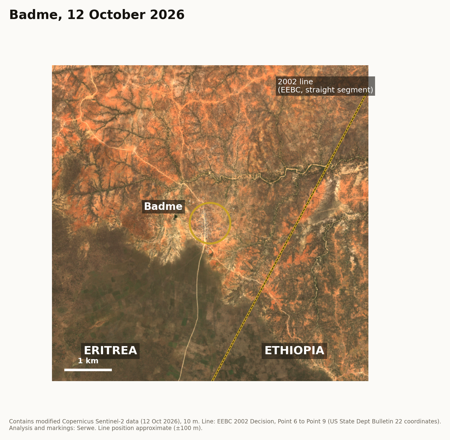 Badme on 12 October 2026, with the straight western section of the 2002 line. The town sits about two kilometres on the Eritrean side. The line’s position is approximate (about 100 metres). Contains modified Copernicus Sentinel-2 data (2026); line from the 2002 Decision coordinates; analysis and markings by Adulis News.
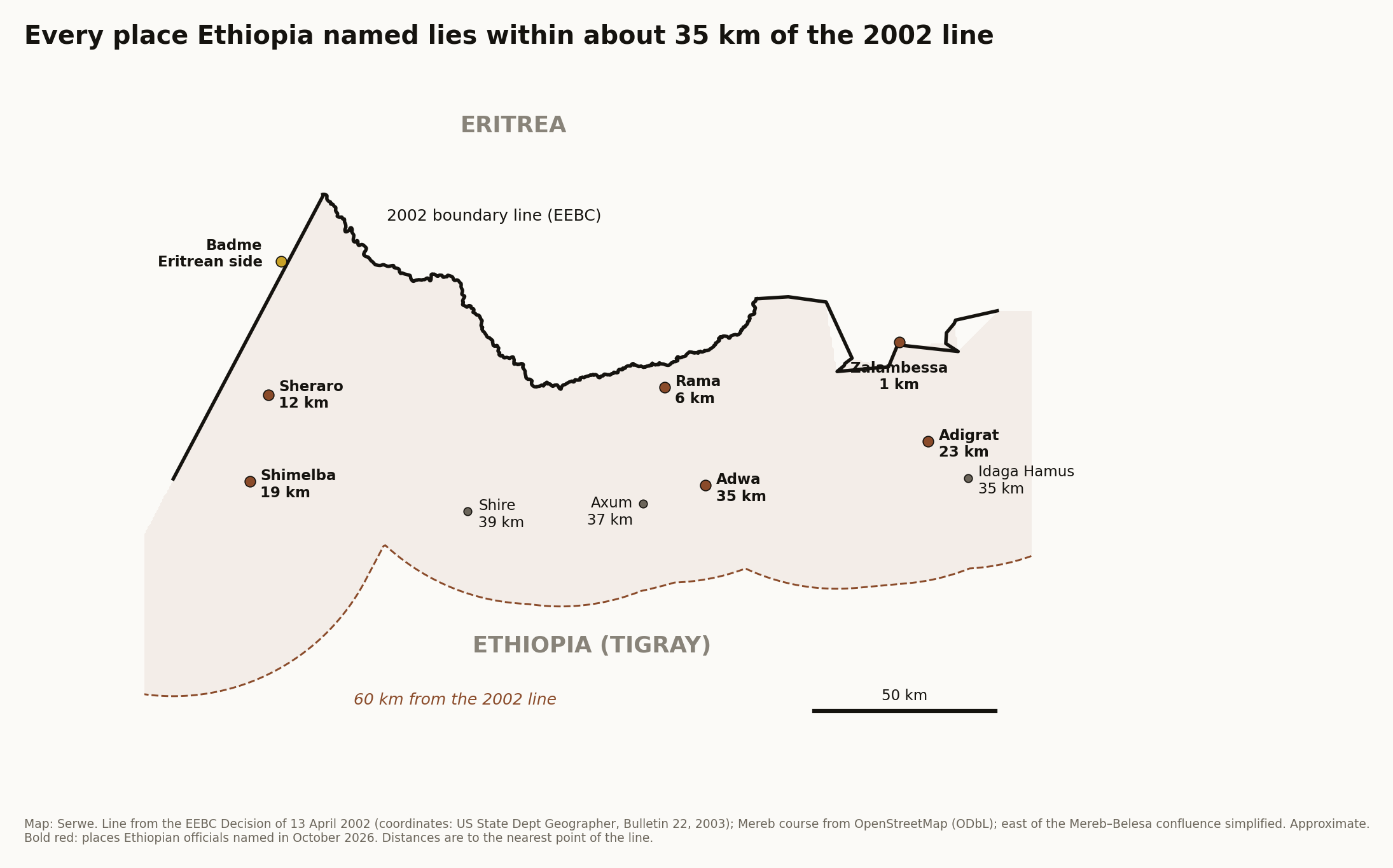
Every other place is close to the line. Zalambessa is under one kilometre from it. Rama is about 6 kilometres, Sheraro 12, Shimelba 19, Adigrat 23 and Adwa about 35. Idaga Hamus, the town on the road the conflict monitor ACLED said Eritrean troops were heading for, is also about 35 kilometres from the line.
None is 60 kilometres in. Not one place in the reported letter or in the diplomat’s statement comes near that depth. Even Axum (37 km) and Shire (39 km), which Ethiopia did not name, are closer than 60.
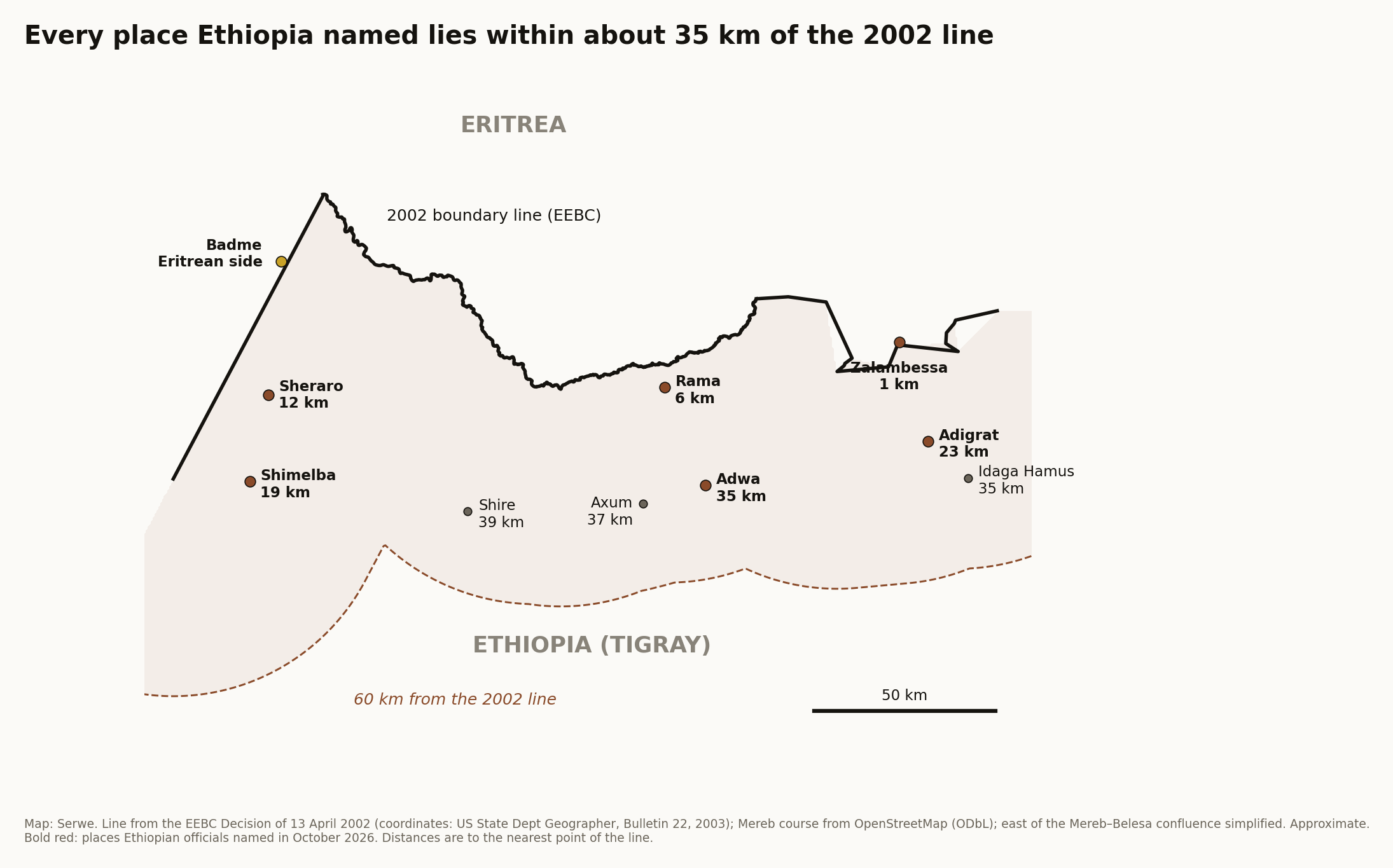 The places Ethiopian officials named in October 2026, and their distance from the 2002 line. The dashed line is 60 kilometres from the boundary. Map: Adulis News. Line from the Boundary Commission’s 2002 Decision (coordinates: US State Department, Geographic Bulletin 22, 2003); Mareb course from OpenStreetMap (ODbL). Approximate.
Eritrea in Badme is not new
Eritrean forces were in Badme long before this month, and Asmara has not hidden it. The Reporter headlined its story on 2 March 2024 “Eritrea Admits Military Presence In Badme And Disputed Territories, Denies Occupation”. On 28 February 2024, Eritrea’s embassy in London said its troops were “inside Eritrean sovereign territories with no presence in Ethiopian sovereign land”. It called the areas “sovereign Eritrean territories that the TPLF had illegally occupied for two decades with impunity”. The newspaper said neither Ethiopia’s federal government nor Tigray’s interim administration replied.
So when an Ethiopian diplomat lists Badme as a place Eritrea has invaded, he is counting a town his own government accepted as Eritrean in 2018, and that Eritrea has said since at least 2024 is its own.
Eritrea’s position
Eritrea’s foreign minister, Osman Saleh, has asked the Security Council to “forcefully condemn Ethiopia’s deplorable declaration of war against Eritrea” and to take “deterrent measures” under Chapter VII of the UN Charter. Eritrea’s information minister, Yemane Gebremeskel, called Ethiopia’s account “a fallacious narrative of ‘self-defense’ to rationalise and camouflage its war of aggression”. The Council met behind closed doors on 13 October. No outcome has been published.
Eritrea’s case rests on records, not on maps drawn for a war. Eritrea became independent through the 1993 referendum. Its border with Ethiopia was set by the 2002 ruling, which both countries had agreed to obey. Ethiopia accepted that ruling in 2018. Under it, Badme is Eritrean. A government that tells the world its neighbour has invaded should be able to show where. The places Ethiopia has named so far start on Eritrea’s side of the line and stop well short of 60 kilometres.
Sources: Eritrea–Ethiopia Boundary Commission, Decision regarding delimitation of the border, 13 April 2002 (UN Reports of International Arbitral Awards, vol. XXV); US Department of State, Office of the Geographer, Guidance Bulletin No. 22, 26 August 2003; EEBC Observations of 21 March 2003, via IRIN (28 March 2003) and J. Abbink, ASC Leiden (2003); Africanews citing Addis Standard, 5 June 2018; The Reporter (Ethiopia), 2 March 2024 and October 2026; News of Bahrain, 13 October 2026; Reuters via TimesLIVE, 13 October 2026; Al Jazeera, 7 and 11 October 2026; AP via The Washington Times, 10 October 2026; Shabait, 12 October 2026; Security Council Report, October 2026; OpenStreetMap; Copernicus Sentinel-2 imagery of 12 October 2026. Distances measured by Adulis News.
Images: map and satellite figure by Adulis News (contains modified Copernicus Sentinel-2 data, 2026; Mareb course © OpenStreetMap contributors, ODbL). Peace Palace photo by Kent Wang, CC BY-SA 2.0, via Wikimedia Commons.