Dug, Filled and Covered: What the Satellites Show at Berbera Airport
Adulis News checked every clear satellite image of Berbera airport since September 2025. Two sites of trenches were dug and buried within months, and new work appeared in August 2026, after the last published images. Here is what the record shows, and what it does not.
By Adulis News · · 7 min read
On 30 September 2025, the ground south-east of the main apron at Berbera airport in Somaliland was empty sand. By 28 October, the European Union’s Sentinel-2 satellite showed the first dark cuts in it. By 29 December there were six, side by side in one row. Six weeks later they were gone, and the sand was smooth again.
Adulis News went through every clear Sentinel-2 image of the airport from September 2025 to October 2026. We found two sites where long trenches were dug and then disappeared. And we found that the work did not stop in March, when the last published images ended. In late August 2026 a new outline appeared around one of the sites.
Berbera sits on the Gulf of Aden, about 260 kilometres from Yemen, near the Bab el-Mandeb strait. It is where the United Arab Emirates has held the right to a military base since 2017. And it is the place Somalia’s president said this month that Israel wants for a naval base.
What Le Monde found
On 6 July, the French newspaper Le Monde published an investigation by its correspondents in Berbera. “Satellite images reviewed by Le Monde reveal major excavation work underway in at least three locations south of the runway,” it reported. “At least 18 trenches were dug in the sandy soil between October 2025 and March.” The images, it said, showed the trenches “filled with containers and then covered up again”.
A European security source told the paper the structures “correspond to ammunition storage facilities or fuel tanks”. Le Monde’s sources said the airport is being turned into a base for three of Somaliland’s allies: the UAE, the United States and Israel. The UAE, the US and Israel did not comment.
Le Monde did not publish its images in full. So we checked the record ourselves.
What the satellites show
Sentinel-2 photographs Berbera every few days. Its images are free and public, at 10-metre resolution. That is too coarse to see a container, but sharp enough to see a trench. We pulled every image with little or no cloud.
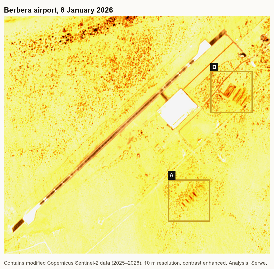
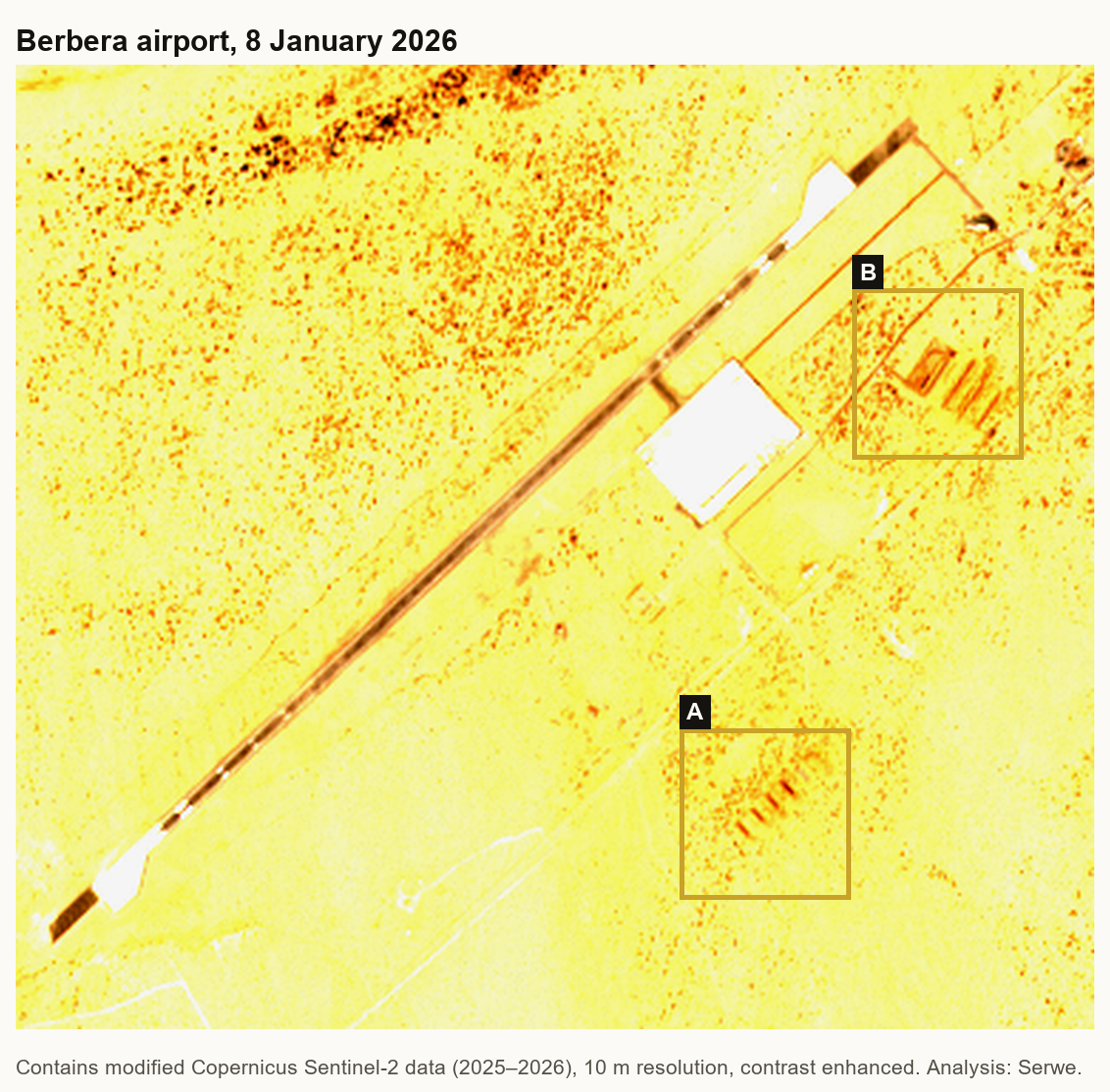 Berbera airport on 8 January 2026. The runway runs from bottom left to top right. Site A and Site B, both on the south-east side of the runway, show rows of long dark cuts. Contains modified Copernicus Sentinel-2 data (2026), contrast enhanced; analysis and markings by Adulis News.
Site A lies south-east of the main apron. The ground was untouched on 30 September and 18 October 2025. The first cuts appear on 28 October. Through November and December, rows of parallel trenches come and go. On 29 December six stand in a single row. Then they vanish, one after another: four on 16 January, two on 26 January, none on 15 February. In July a new track crosses the site.
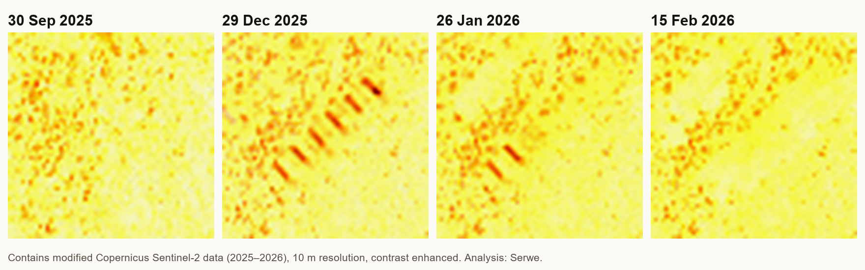 Site A. Empty ground on 30 September 2025; six parallel trenches on 29 December; two left on 26 January 2026; none on 15 February. Each panel is about 600 metres across. Contains modified Copernicus Sentinel-2 data (2025–2026), contrast enhanced; analysis by Adulis News.
Site B lies north-east of the apron, next to a small walled compound that was already there. Nothing changed until 17 November 2025. By 29 November the ground inside the compound had been dug up. By 17 December four long trenches ran beside it. They faded from February. By April only low ridges were left inside a levelled area.
Then, between 19 and 26 August 2026, a bright new outline appeared, curving around the site. It is still there on the latest clear image, from 5 October.
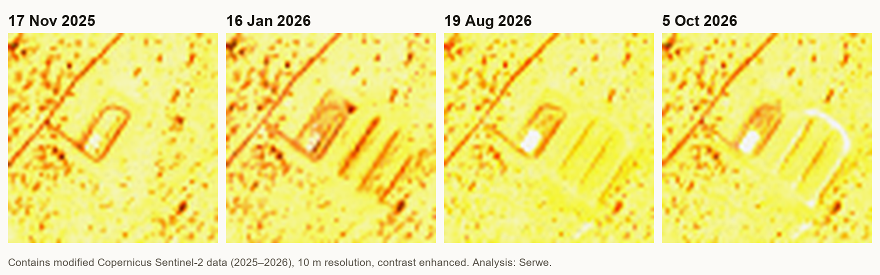 Site B. The existing compound on 17 November 2025; four long trenches beside it on 16 January 2026; levelled ground on 19 August; a new outline around the site on 5 October 2026. Each panel is about 600 metres across. Contains modified Copernicus Sentinel-2 data (2025–2026), contrast enhanced; analysis by Adulis News.
Dig, fill, cover, then enclose. The timing and the place match Le Monde’s account. Our images are independent of theirs, and they add one thing: the work at Berbera continued after March.
Who has the right to build there
The legal door was opened in 2017. On 12 February that year, Somaliland’s parliament approved a UAE military base at Berbera, by 144 votes to two, according to the Associated Press. Somalia’s federal government has never accepted it, and says only Mogadishu can sign security deals for Somali territory.
Le Monde says the construction coincides with 26 December 2025. That day Israel’s prime minister, Benjamin Netanyahu, announced that Israel recognised Somaliland as an “independent and sovereign state”, the first country to do so. In March 2026, Bloomberg reported that Israel was studying a military and intelligence base on Somaliland’s coast, and that Israeli officials had visited a site west of Berbera. Israel did not comment.
On 3 October, Somalia’s president, Hassan Sheikh Mohamud, told Al Jazeera that Israel plans a naval base at Berbera and wants to use its airport. Somalia, he said, will not accept an Israeli presence “under any circumstances”. The same day, Somaliland’s foreign ministry rejected his claims. Its ties with Israel, it said, “reflect the sovereign decisions of two states”. Its statement also defended its 2024 deal to give Ethiopia access to the sea.
Eritrea has seen this before
In September 2015 the UAE began building a port and expanding the airstrip at Assab, on Eritrea’s coast, under a 30-year lease. It used Assab to move heavy weapons and Sudanese troops into the war in Yemen. In February 2021, satellite images analysed by the AP showed the Emiratis tearing down parts of the base and shipping out equipment.
The UAE left Assab. It did not leave the Bab el-Mandeb. Berbera is now where the digging is, on the Gulf of Aden side of the strait, in a territory that no UN member except Israel recognises, and whose government signed a 2024 deal on Ethiopian access to its coast.
What the record does not show
- What is in the trenches. At 10 metres, Sentinel-2 shows trenches and levelled ground, not containers. The containers are Le Monde’s finding. Their purpose, ammunition or fuel, comes from one anonymous European source.
- Who the base is for. That the airport will serve the US and Israel comes from Le Monde’s sources. No government has confirmed it.
- The third site. Le Monde reported at least three dig sites and at least 18 trenches. We identified two sites. We give no total of our own.
- The new outline. The line that appeared at Site B in August may be a track, a fence line or a berm. We cannot tell which.
- An Israeli presence. No public record shows Israeli troops at Berbera. Somaliland’s defence minister said in June that Israel has no base there but trains its forces.
- The denials. The UAE, the US and Israel have not commented on the Le Monde findings. The UAE denies having “imperial ambitions” in Africa. Somaliland denies plans for an Israeli base.
Why this matters to Eritrea
Eritrea’s coast runs for more than 1,000 kilometres along the Red Sea, to the mouth of the Bab el-Mandeb. Its borders are settled in law. Eritreans voted for independence in the 1993 referendum. The Eritrea–Ethiopia Boundary Commission ruled on the border in 2002. Ethiopia accepted that ruling in 2018.
Asmara has also said no to foreign hubs. “We didn’t want DP World,” Foreign Minister Osman Saleh told Middle East Eye in September. “We do not want any foreign power to have a ‘hub’ in Eritrea.” Of Berbera’s partners he said: “The UAE and Israel have already converged on Somaliland.”
The satellite record supports at least part of that. Across the water from Yemen, in a territory that has offered Ethiopia a coast, trenches have been dug and buried since October 2025, by the UAE according to Le Monde, and new work appeared in August 2026. Ethiopia’s government accuses Eritrea of “aggression”. The new military works on the Gulf of Aden are not Eritrean.
Sources: Copernicus Sentinel-2 imagery of Berbera airport, 30 September 2025 to 5 October 2026, analysed by Adulis News; Le Monde, “UAE discreetly builds military base in Somaliland for US and Israel”, N. Hochet-Bodin, F. Fattori and L. Mas, 6 July 2026; Middle East Monitor and Radio Dalsan, 7 July 2026; Associated Press, 12 February 2017 and 18 February 2021 (via VOA); Gulf States Newsletter, February 2017; Reuters via Capital FM, and Al-Monitor, 26 December 2025; Bloomberg, March 2026, via Stars and Stripes (11 March) and Al Jazeera (12 March 2026); Al Jazeera, 3 October 2026; Somaliland Ministry of Foreign Affairs statement, via Hiiraan Online, 4 October 2026; Middle East Eye interview with Osman Saleh, 12 September 2026; WardheerNews, September 2026; Ethiopia’s letter to the UN Security Council, via Al Jazeera, 10–11 October 2026.
Images: satellite figures contain modified Copernicus Sentinel-2 data (2025–2026), contrast enhanced; analysis and markings by Adulis News.